

10 Things to Know About Hurricane Florence and Ghiorse's Insights
GoLocalProv News Team
10 Things to Know About Hurricane Florence and Ghiorse's Insights
According to the National Hurricane Center, the storm is expected to make landfall by Thursday morning and could be as strong as a Category 3 storm by the time it hits land.
GoLocal's John Ghiorse says, "Large and very dangerous Hurricane Florence continues to lumber toward the East Coast. The forecast of the track of the storm has been very consistent bringing it into the North Carolina coast sometime later this week. Normally we here in Southern New England would be mightily concerned that the storm could turn and head in our direction. But this time there is a strong ridge of high pressure that extends from out over the Atlantic Ocean westward nosing into the Northeastern United States," says Ghiorse.
GET THE LATEST BREAKING NEWS HERE -- SIGN UP FOR GOLOCAL FREE DAILY EBLAST
“Florence is likely to produce a life-threatening storm surge along the coastlines of South Carolina, North Carolina & Virginia, and a Storm Surge Watch is in effect for a portion of this area,” said the National Hurricane Center.
According to the Washington Post, more than 1.5 million people have been ordered to evacuate the coastal areas ahead of the storm.
See 10 Things to Know About Hurricane Florence in the Slideshow Below
10 Things to Know About Hurricane Florence - September 2018

Florence Making Landfall
According to the National Hurricane Center, the storm is expected to make landfall by Thursday morning and could be as strong as a Category 3 storm.
However, the center adds that there is a chance the storm reaches land by late Wednesday night.
"The earliest reasonable time that tropical-storm-force winds could arrive in the United States from #Florence is late Wednesday, and the most likely time is Thursday morning. Wednesday should be the last full day to prepare, so plan accordingly," said the Hurricane Center.
PHOTO: National Hurricane Center

58 MPH Winds Possible
Hurricane Florence could bring winds up to 58 miles per hour to the Carolinas and Virginia.
"Florence is likely to cause damaging hurricane-force winds along parts of the coasts of South & North Carolina, & a Hurricane Watch is in effect for some of this area. Damaging winds could also spread well inland into portions of the Carolinas & Virginia," said the National Hurricane Center.
PHOTO: National Hurricane Center

Evacuations Under Way
Evacuation has already started in the Carolinas with Hurricane Florence about to hit.
According to the Washington Post, more than 1.5 million people have been ordered to evacuate the coastal areas ahead of the storm.
“Even if you’ve ridden out storms before, this one is different,” said North Carolina Governor Roy Cooper during a press conference on Tuesday.
In order to speed up the process, the lanes of the highways have been reversed in order for everyone to be able to get out.
North Carolina Emergency Management adds that prisons are evacuating staff and offenders to other state facilities due to Hurricane Florence.
Offenders will be given a free call to families this weekend.
PHOTO: Ross Arnette/twitter

NOAA Plane Flies Through Florence
A plane from the National Oceanic and Atmospheric Administration flew through the eye of the storm.

Rainfall Potential from Hurricane Florence
According to the National Hurricane Center, some parts of the Carolina's could see up to 20 inches of rain.
According to the chart, most of the area will see at least six to ten inches of rain.
The Center notes that the forecast is valid until Tuesday, September 18 at 8 p.m.

Flash Flood Potential
The National Hurricane Center chart shows that the majority of the area has a marginal to slight chance for flash flooding.
However, areas right along the coast have a moderate to high percent chance of flooding.
The forecast is valid through Friday, September 14.

President Trump Addresses Florence
President Donald Trump addressed Hurricane Florence in a press conference from the Oval Office on Tuesday, September 11.
"They haven't seen anything like what's coming at us in 25, 30 years, maybe ever. It's tremendously big and tremendously wet," said Trump.
Trump went on to advise everyone to get out of Florence's path.

Biggest Storm Ever North of Florida
Hurricane Florence could be the biggest hurricane ever to hit north of Florida, according to Business Insider.
The biggest hurricane to previously hit South Carolina was Hurricane Hugo in 1989.
That hurricane brought 130 mph winds.

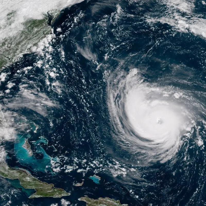
Hurricane Florence
Here is a scientific look at Hurricane Florence as it approaches the Carolinas.

More Storms Coming
While Florence is the primary focus along the east coast, there are more storms potentially on the way.
A chart from the National Oceanic and Atmospheric Administration shows that Hurricane Isaac and Hurricane Helene are out at sea.
While still a little ways away, Isaac is currently carrying 70 mph winds and is moving west.
Helen is carrying 110 mph winds and is moving northwest.
PHOTO: National Oceanic and Atmospheric Administration


