

The Skiing Weatherman Conditions Report: Feb 26-Mar 2
Herb Stevens, GoLocalProv's Skiing Weatherman
The Skiing Weatherman Conditions Report: Feb 26-Mar 2

After a brief interlude of more spring-like weather with milder temperatures and some rain late last week and over the weekend, colder air is on the march southeastward from Canada and will become the dominant air mass over the Northeast until further notice. In the wake of the cold front that moved through Friday night, the air wasn’t initially all that cold, and that was a blessing. Why? Well, several times this year we have seen mild, damp weather followed immediately by a direct discharge of pure arctic air, which turned surfaces shiny and firm...a gentler way of saying it became pure ice! This time, the incoming air mass was not cold enough to keep daytime temperatures below freezing, and surface conditions, while certainly more moist than the wonderful packed powder we have enjoyed much of February, were very carveable for the most part. Many states were wrapping up school vacations, while others were getting theirs underway, and from a business standpoint, the relatively mild temperatures were a very positive development for skiers, riders, and the resorts.
Midweek Forecast
GET THE LATEST BREAKING NEWS HERE -- SIGN UP FOR GOLOCAL FREE DAILY EBLASTNow that cold air has returned, the surfaces have firmed up, to be sure, but over the next several days, there will be several ways for light snow to be generated over the Northeast and that will help morph the surfaces back to packed powder by later this week. As a new upper level trough develops over the region, the cold pool aloft associated with that trough will help trigger rather persistent mountain snow showers the next couple of days. Meanwhile, a series of fast moving upper level disturbances will race from west to east across the country in what has become a very fast moving split flow jet stream pattern. They will contain very limited moisture and thus have limited potential for producing significant snow, unless the northern and southern branches of the jet come together and phase. That combination of jet energy would help dig a deeper trough along the eastern seaboard, which would in turn help any surface low pressure center that forms to our south hug the coast to a greater degree, which would spread snow further inland. The first shot at such a system will come midweek, and right now, it looks as though the surface low will pass too far southeast of New England to be much of a storm for the resorts. That said, I think we will see a light to perhaps moderate snowfall develop because of a phenomenon known as a “Norlun” trough. The name Norlun comes from the two NOAA meteorologists (Steve NOguiera and WeiR LUNstedt) that did the research and identified the parameters necessary for one of these events. In short, a Norlun trough is an extension of a low pressure area that misses too far offshore. It looks like this on a surface map...
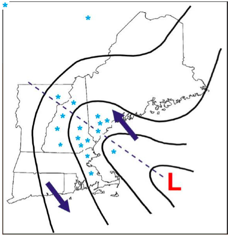
The counter clockwise circulation around the ocean low helps pump moisture northwestward and onshore. If the air aloft from roughly 5,000 to 20,000 feet over the land is colder than normal, as it will be this week, it becomes unstable, which helps jack up the snowfall rate. The result is often a narrow band of snow that can become quite heavy for a period of time. The band tends to propagate from southwest to northeast as the low heads toward the Maritimes. The best conditions for a productive Norlun trough are found over Maine, as the surface low is generally stronger when it gets to that latitude, and it has had a longer time to generate the onshore fetch that moistens up the atmosphere. While this doesn’t look like an ideal set up, we should see light snow over much of New England and eastern New York on Wednesday, and that will help with the process of softening the surfaces.
This Weekend and Long Term
The next shot at snow will come over the weekend, when a disturbance in the southern branch of the jet stream will approach the eastern seaboard and spawn a surface low in the waters down by North Carolina. There is a real question as to whether or not the system will be able to turn the corner sharply enough to impact the Northeast...right now I would lean against it. As was the case early in February when the polar vortex made an approach to the Great Lakes from the north, the cold air will tend to suppress the storm track, and my feeling is that while the Northeast will pick up fresh snow here and there in the next week, any heavier snow will be found in the central Appalachians and mid-Atlantic regions. Next week, when the PV will retreat somewhat to the north, I think we will have a better chance at seeing a substantial storm run the coast and bring us a late season powder day. Longer term, the signs are strong that another cold trough will develop over eastern North America about two weeks from now, which should keep the season chugging along by keeping temperatures cold enough to preserve snow and present us with more opportunities for sizable storms. March looks colder than normal to me, much like last March was, and there will be enhanced potential for snowfall over the next 2-3 weeks, so make your plans to make another trip or two to the slopes...spring is nowhere in sight!
Upcoming Events
Here’s a rundown of some special events coming up on the slopes:
Nashoba Valley, MA--Throwback Day 2/27...$2.50 lift tickets!!!
Wachusett MT., MA--Ralph Crowley Classic Race 2/28...Slopestyle Comp.--3/1 Sugarloaf, ME-FIS giant slalom on 2/27 and 2/28
Sunday River, ME--USASA 1⁄2 pipe 3/2
Attitash, NH--Skier/Boardercross 3/1
Wildcat, NH--RAMP Sports Demo Day 3/1
Bretton Woods, NH--Snow Kite Fest 3/1 and 3/2
Crotched MT., NH--10th Annual big air and style competition 3/1
Bromley, VT--Telemark Nationals 2/27 and 2/28
Winter Activities

Ice skating
Satisfy your inner child and pull out those ice skates this weekend. Take your significant other or the whole family to the Providence Rink for hours of winter fun! Afterwards, take a downtown stroll to view the holiday lights with a cup of hot cocoa.
2 Kennedy Plaza, Providence, RI.
Photo: Elvert Barnes/Flickr

Bristol
Take the trip to Bristol this weekend to enjoy the festivities. Take a Christmas tour of Linden Place Mansion to see the lavish decorations. On Saturday, Linden Place will also be hosting Christmastime stories with Robb Dim, reminiscent of Christmases past. Also in Bristol is Blithewold Mansion, Gardens & Arboretum. Be sure to visit and see Christmas at Blithewold, their annual Christmas celebration featuring caroling, music, lights, decorations and more.
Linden Place Mansion, 500 Hope Street, Bristol, RI. (401) 253-0390.
Blithewold Mansion, 101 Ferry Road, Bristol, RI. (401) 253-2707.
Photo: Jbarta

Holiday Pops
Go to see the world-renowned Boston Pops Esplanade Orchestra this Friday, December 13 right here in Providence. The Orchestra will be performing their Holiday 2013 concert, also featuring the Metropolitan Chorale of Brookline at the Providence Performing Art Center. Make sure to grab your tickets before they’re gone.
200 Weybosset Street, Providence, RI. (401) 421-ARTS.
Photo: Marc N. Belanger

Holiday Gardening
Take a much-needed breather from the craziness of the holidays to try something new. This Friday, December 13, take a fun holiday horticulture class: Demystifying Holiday Houseplant Care that will be sure to cure all of your winter gardening woes. Learn all about how to pot and maintain winter plants, from amaryllis to cyclamen. Registration is mandatory.
Blithewold Mansion, 101 Ferry Road, Bristol, RI. (401) 253-2707.
Photo: Jon Ward/Flickr

Celtic Christmas
A Celtic Christmas at Linden Place Mansion in Bristol is a multi-faceted celebration that honors not only Christmas, but also the winter solstice. Listen to an array of Kilmore carols and authentic Irish music honoring both Christmas and Pagan traditions. The show will be performed fireside in the carriage house ballroom of Linden Place. Before the show, enjoy a special romantic seaside dinner exclusively for concertgoers at DeWolf Tavern including a three-course dinner and a glass of beer or wine for under $20!
Linden Place Mansion, 500 Hope Street, Bristol, RI. (401) 253-0390.
DeWolf Tavern, 259 Thames Street, Bristol, RI. (401) 254-2005.
Photo: Sebastian Dooris/Flickr

Newport
Newport has been enchanting visitors for centuries, and there is no better time to visit than during the magic of the holiday season. This year marks the 43rd annual Christmas in Newport celebration. Visitors are treated to an old fashioned seaside Christmas as they stroll the city streets. Highlights of this weekend of the festival include The Polar Express Train Ride, a holiday craft fair, holiday lantern tours of Historic Newport, foodie events and more. See the event website for a full listing of events.
Newport, RI. Click here for more.
Photo: Jessica Curtin/Flickr

Theatre
Take a trip to Stadium Theatre and the Nazarian Center for the Performing Arts at Rhode Island College to experience the best in holiday theatre productions. Head to Stadium Theatre in Woonsocket for their showing of a holiday classic, “A Christmas Carol” Friday, Saturday or Sunday. On Friday, see the Providence Ballet’s rendition of “’Twas the Night Before Christmas” at the Nazarian Center for the Performing Arts in Providence.
Stadium Theatre, 28 Monument Square, Woonsocket, RI. (401)762-4545.
Nazarian Theatre for the Performing Arts, 600 Mount Pleasant Avenue, Providence, RI. (401) 456-8000.
Photo: a4gpa/Flickr

Winter Solstice Party
Celebrate the impending Winter Solstice tonight at The Marine Museum at Fall River. This great party will include music by the Spindle Rock River Rats, refreshments, a lighting of the 28’ Titanic model, refreshments and more. Get out and enjoy this family friendly holiday event.
70 Water Street, Fall River, MA. (508) 674-3533.
Photo: Caryatidxx/Flickr

Wine
This Saturday, Greenvale Vineyards in Portsmouth is holding their 14th Annual Warm Up for the Holidays Open House. Take a break from the holiday planning to attend the event—it is sure to be a crowd pleaser. Highlights of the event include local food samples, vineyard tours, live music, and, of course WINE tastings!
582 Wapping Road, Portsmouth, RI. (401) 847-3777.
Photo: Kyknoord/Flickr

Holiday Arts
Enjoy beautiful art crafted by local, regional, and national artisans this weekend at two great events at Tiverton Four Corners Arts Center. On Saturday, attend the opening of their holiday exhibit, “re-Tree.” This great exhibit showcases holiday trees created with recycled materials. After you browse the exhibit, stroll through the Winter Arts + Artisan Fair, also at Tiverton, and even pick up a handmade gift.
3852 Main Road, Tiverton Four Corners, RI. (401) 624-2600.
Photo: Crabchick/Flickr


