

The Skiing Weatherman Conditions Report: January 30-February 2
Herb Stevens, GoLocalProv's Skiing Weatherman
The Skiing Weatherman Conditions Report: January 30-February 2
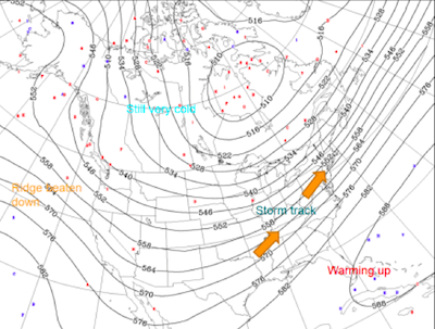
The tight packing of the lines that you see between the two features is consistent with a fast flow, and even though we have fought our way through a number of storms that produced a mixed mess of precipitation types, it never took very long after any warm-up before cold rushed in and got the snowmakers back on the job. While the cold has certainly been welcomed, in the past ten days or so, we have had too much of a good thing. The northwesterly flow of arctic air has been so strong, it has suppressed the storm track well to the south, and the only snowfall most of the Northeast has received has come from moisture-starved Alberta Clipper lows. A great example of the suppressed storm track will unfold this week, when low pressure brings appreciable snow to portions of Georgia, South Carolina, and North Carolina...the storm will track out to sea before it gets anywhere near the Northeast.
GET THE LATEST BREAKING NEWS HERE -- SIGN UP FOR GOLOCAL FREE DAILY EBLASTThe month ahead
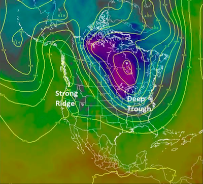
Now, when we get to February, most resorts would like to be able to roll up the hoses, blowout the pipes, and shut down the snowmaking systems, because those machine made crystals aren’t cheap. Base depths are not as deep as most operators would like to see them heading into the second half of the season, so most will continue to make snow whenever possible. The good news from a weather standpoint is that the pattern is about to undergo a change that will lead to a very stormy February, one that I believe will bring above normal snowfall amounts to much of the eastern United States. The main reason for the change will be a shift in the jet stream setup, and to illustrate what that shift will look like, here is a forecast for ten days from now that I agree with...
In the shorter term, the first half of this week will be very cold, but with an extra layer of clothing, you’ll be able to take advantage of smaller midweek crowds and some very nice snow. Temperatures will start to modify later in the week, and as the jet stream relaxes and turns more westerly, the parade of low pressure systems should get underway, with some light snow across the mountains a pretty good bet early in the upcoming weekend...that should just be the start of a very snowy February.
Events/specials over the next week:
LOON MOUNTAIN, NH-USASA Slopestyle 2/1
CANNON MT., NH-Big Air Contest 2/1
WATERVILLE VALLEY, NH-Reggae Fest 1/31, Fireworks in Town Square 2/1
CROTCHED MT., NH-Midnight Madness 1/31, 2/1...ski or ride until midnight
Best Ski + Snowboard Colleges in the East

Middlebury College
Middlebury, VT
With Stowe and Sugarbush nearby, finding challenging terrain is not an issue at colleges in northern Vermont. Students at Middlebury enjoy the Snow Bowl, owned by the college, for a quick few runs when they are not up for a car ride. In less than a half hour however, they can hit the slopes at Sugarbush or Stowe. You will need to be a top student to get into Middlebury though; with an acceptance rate of just 17%, the college is among a handful of the most selective liberal arts colleges in the country.

University of Vermont
Burlington, VT
Heading north, in the picturebook city of Burlington on the shores of Lake Champlain, you will find the University of Vermont. Famous for producing both Alpine and Downhill Olympic skiers, UVM is a mecca for winter sports lovers. Buses head from campus to the slopes on the weekends, and students tune their skis in the dorm hallways at night. Sugarbush and Stowe are the most popular ski destinations for UVMers, but Smuggler’s Notch and Jay Peak also draw sports classes and snowboarders looking for slopes off the beaten path. UVM is different than most state schools in that 75% of students come from out-of-state, the university boasts an amazing honors college, it’s home to a ground breaking environmental studies program and a highly rated medical school.

St. Michael's College
Colchester, VT
Nearby in Colchester, St. Michael’s is a hidden gem among Catholic colleges in New England. St. Mike’s has a warm, pretty campus with a wide variety of majors, including business. Easy access to Burlington and all the same ski areas as UVM, make St. Mike’s a great option for students wanting a small college with reasonable acceptance rates and a nurturing academic environment.

Dartmouth College
Hanover, NH
For skiers and snowboarders who can make the Ivy League cut, there is really only one college: Dartmouth. Whether you race cross country or are a downhill enthusiast, Dartmouth’s long tradition of elite athletics will ensure top notch competition. Dartmouth has their own “SkiWay”, but it’s not on campus and most students prefer the challenge of a bigger mountain. Since Dartmouth sits close to the New Hampshire/Vermont boarder, there are quite a few options for big mountain skiing, with Killington and Okemo less than 45 minutes away.

New England College
Henniker, NH
New England College in Henniker is a tiny, ski lovers’ gem. For students who prefer a small college with very personal attention, NEC is a great choice. Those with learning differences will also find a warm and accepting environment with professor mentorships and all the tools necessary to succeed in college. Students at NEC form a tight knit community and can often be seen heading off with boards tucked under their arms in groups each afternoon to hit the slopes at nearby Loon or Waterville.

Plymouth State University
Plymouth, NH
Plymouth State offers another option for boarders and skiers in central New Hampshire. With easy access to Waterville, Loon, Cannon and even the North Conway area, there are many choices for big mountain skiing. The college sprawls up the hillside in the quaint town of Plymouth, which is filled with shops and restaurants. With a medium size student body, reasonable acceptance rate and low tuition, Plymouth State is easily accessible for many students.


