

NEW: Bruins Parade Route Info
GoLocalProv Sports Team
NEW: Bruins Parade Route Info
According to the Boston Bruins and the City of Boston - here is all the news you need to know to join the parade - directions, time, and the offical City of Boston map.
The rolling rally parade to celebrate the Stanley Cup Champion Boston Bruins will begin at the TD Garden on Saturday, June 18, beginning at 11:00 AM and end at Copley Square.
GET THE LATEST BREAKING NEWS HERE -- SIGN UP FOR GOLOCAL FREE DAILY EBLAST
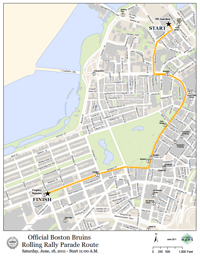
The rally will feature duck boats and will proceed along the following route:
* Causeway Street
* Left on Staniford Street
* Left on Cambridge Street
* Right on Tremont Street
* Right on Boylston Street
* End at Dartmouth Street
Parking restrictions across the city will be heavily enforced in the vicinity of the closed off parade route streets and fans are strongly encouraged to use public transportation. To accommodate the celebration, vehicular traffic will be banned along the parade route beginning at 9:00 AM until the conclusion of the parade at about 1:00 PM.
“Boston Police will also have a significant presence along the parade route as part of a comprehensive strategy to ensure everyone’s safety and I encourage fans to continue making the city proud and honoring the Bruins by celebrating responsibly,” Boston Police Commissioner Edward Davis said.
Temporary parking restrictions will be put into effect at several locations throughout the city and vehicles parked in violation will be ticketed and/or towed. Temporary “Tow Zone No Stopping Boston Police Special Event Saturday” regulations will be posted at the following locations:
* Canal Street, from Causeway Street to New Chardon Street
* Friend Street, from Causeway Street to New Chardon Street
* Portland Street, from Merrimac Street to Causeway Street
* Lancaster Street, from Causeway Street to Merrimac Street
* Merrimac Street , from Causeway Street to Lancaster Street
* Causeway Street, from North Washington Street to Merrimac Street
* Staniford Street, from Causeway Street to Cambridge Street
* Cambridge Street, from Hancock Street to Tremont Street
* Tremont Street, from Cambridge Street to Boylston Street
* Boylston Street, from Washington Street to Dalton Street
* New Chardon Street, from Cambridge Street to Merrimac Street
* Bowdoin Street, from Cambridge Street to Derne Street
* Somerset Street, from Cambridge Street to Ashburton Place
* New Sudbury Street, from Cambridge Street to Bulfinch Place
* Court Street, from Cambridge Street to Court Square
* Beacon Street, from Tremont Street to Somerset Street
* Bromfield Street, from Province Street to Tremont Street
* Park Street, from Tremont Street to Beacon Street
* Temple Place, from Tremont Street to Washington Street
* West Street, from Tremont Street to Washington Street
* Essex Street, from Tremont Street to Washington Street
* Charles Street South, from Park Plaza to Center gate of Public Garden
* Hadassah Way, from Boylston Street to Park Plaza
* Berkeley Street, from St. James Avenue to Newbury Street
* Clarendon Street, from Newbury Street to St. James Avenue
* Dartmouth Street, from Boylston Street to Newbury Street
* St. James Avenue, from Clarendon Street to Dartmouth Street
To protect the safety of residents and guests, the Boston Police Department may further restrict vehicle parking and limit vehicular and pedestrian access.