

The Mystery of RI's Pancake and Gingerbread Islands
GoLocalProv News Team
The Mystery of RI's Pancake and Gingerbread Islands
The islands are often seen but few pay attention to their existence and infamous -- and racist -- Rhode Island writer H.P. Lovecraft linked them to pirate treasure.
"H. P. Lovecraft was once something of a waterman on the Seekonk River, seen in a Whitman Bailey drawing made on the Poe-haunted west shore at Blackstone Park," writes David Haden.
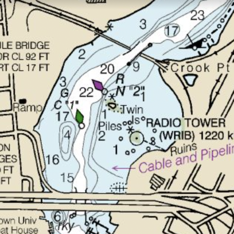
GET THE LATEST BREAKING NEWS HERE -- SIGN UP FOR GOLOCAL FREE DAILY EBLAST“I used to row considerably on the Seekonk … Often I would land on one or both of the Twin Islands — for islands (associated with remote secrets, pirate treasure, and all that) always fascinated me.” — Lovecraft letter to Rimel, April 1934.
Gingerbread and Pancake Islands are mere spits of land just to the north of the Washington Bridge on I-195, in the Seekonk River between Providence and East Providence.
If you search on Google Maps, you will see them marked as Pancake and Gingerbread Islands. They are not, however, named on navigational charts produced by the National Oceanic and Atmospheric Administration (NOAA).
So where -- and when -- did they get those names?

NOAA however was able to shed a little more light.
Colleen Roche is NOAA’s Navigational Manager for Rhode Island and provided GoLocal with some historical perspective.
About Islands
Roche confirmed that the U.S. Board of Geographic (UBG) Names lists the islands as Pancake and Gingerbread — as well as under “Twin Islands.”
Pancake and Gingerbread Islands were entered into the United States Geographical Survey in 1991 — but were officially deemed those names in a UBG decision in 1930.
Other variant names that were listed by the USGS? “Cup-Cake Islands.”
“The US Board of Geographic Names (BGN) referenced the Official Gazetteer of Rhode Island printed in 1932 as the source for the names,” said Roche.
The document provides the following context — and stated at the time that the names of the islands were not, in fact, one of the baked goods.

Pancake: island, the eastern of the Twin Islands group in Seekonk River about half mile above mouth, in Providence. (Not Bullock, Cup-Cake, nor Pan-Cake).
Roche said she was unable to find the notes from the February 5, 1930 meeting in which they were formally adopted by the Board of Geographic Names, and suggested it would require further research.
Updating Derogatory Names
In her capacity at NOAA, Roche also told GoLocal she has seen an increase in proposals from the public to rename geographic features or places with derogatory names.
In Rhode Island, a brook in Coventry officially named the “N-word Sawmill Brook” in 1930 was changed to “Negro Sawmill Brook” in 1972.
It was officially changed to just “Sawmill Brook” in 2020.