

Latest Friday Storm Forecast -- 4-8 Inches of Snow, Potential for "Flash Freeze"
GoLocalProv News Team
Latest Friday Storm Forecast -- 4-8 Inches of Snow, Potential for "Flash Freeze"
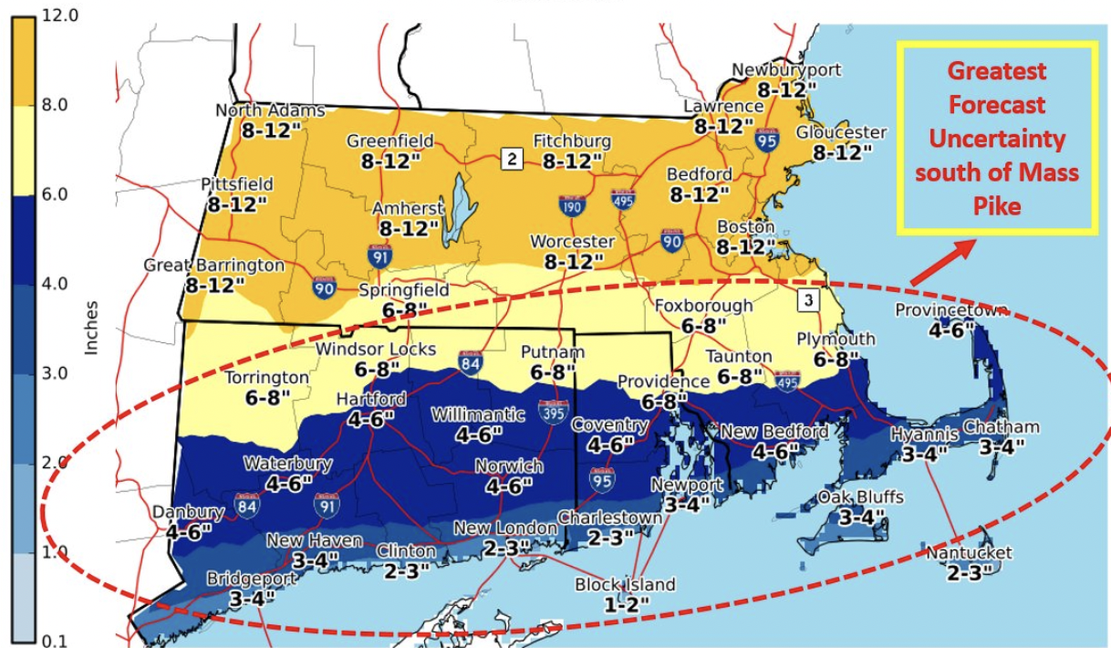
The National Weather Service is now predicting 4-8 inches of snow for Rhode Island and southern New England on Friday.
According to NWS, the snow, which is expected to start early Friday morning, could turn to rain and sleet, resulting in a "flash freeze."
GET THE LATEST BREAKING NEWS HERE -- SIGN UP FOR GOLOCAL FREE DAILY EBLAST
Winter Storm Watch
URGENT - WINTER WEATHER MESSAGE
National Weather Service Boston/Norton MA
254 AM EST Thu Feb 24 2022
CTZ002>004-MAZ017>019-RIZ001>004-242100-
/O.CON.KBOX.WS.A.0008.220225T0500Z-220226T0500Z/
Hartford CT-Tolland CT-Windham CT-Northern Bristol MA-Western Plymouth MA-Eastern Plymouth MA-Northwest Providence RI-Southeast Providence RI-Western Kent RI-Eastern Kent RI-
Including the cities of Hartford, Windsor Locks, Union, Vernon,Putnam, Willimantic, Taunton, Brockton, Plymouth, Foster, Smithfield, Providence, Coventry, West Greenwich, East Greenwich, Warwick, and West Warwick
254 AM EST Thu Feb 24 2022
...WINTER STORM WATCH REMAINS IN EFFECT FROM LATE TONIGHT THROUGH
FRIDAY EVENING...
* WHAT...Heavy mixed precipitation possible. Total snow
accumulations of 4 to 8 inches and ice accumulations of a light
glaze possible.
* WHERE...Portions of northern Connecticut, southeastern
Massachusetts and northern Rhode Island.
* WHEN...From late tonight through Friday evening.
* IMPACTS...Travel will be be very difficult especially for the
Friday morning commute. A flash freeze is expected later Friday
afternoon and early evening across Rhode Island and southeast
Massachusetts.
* ADDITIONAL DETAILS...Snow will overspread the region between 1
and 4 am Friday morning. The snow will quickly become heavy
falling at the rate of 1 to 2 inches per hour at times through
daybreak Friday. The snow will change to sleet from south to
north Friday morning and some light freezing rain is possible
across northern Connecticut and northwest Rhode Island.
Precipitation may change to a period of plain rain across far
southeast New England. Mixed precipitation will change back to
all snow before ending later Friday afternoon and early evening.
This will result in a flash freeze across portions of Rhode
Island and Southeast Massachusetts.
PRECAUTIONARY/PREPAREDNESS ACTIONS...
Monitor the latest forecasts for updates on this situation.