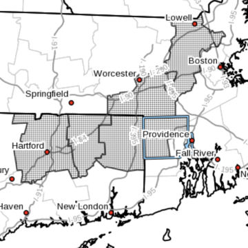
2-4 Inches of Snow Possible in Northern RI on Wednesday - Flood Watch Issued for Rest of State
Wednesday, January 25, 2023
The Rhode Island Emergency Management Agency has warned those traveling in northern Rhode Island on Wednesday of snowy -- and slippery -- conditions.
RI EMA Tweeted the following:
"Winter weather advisory in effect for northern #RhodeIsland from 1:00 pm Wednesday to 1:00 am Thursday.
GET THE LATEST BREAKING NEWS HERE -- SIGN UP FOR GOLOCAL FREE DAILY EBLAST2-4" of snow expected. Plan on slippery road conditions. Slow down and use caution when driving. #BeSafe #BePrepared #RIwx"
In addition, the National Weather Service issued the following flood watch for Rhode Island.
Flood Watch
National Weather Service Boston/Norton MA
228 PM EST Tue Jan 24 2023
MAZ013>021-RIZ001>007-251100-
/O.NEW.KBOX.FA.A.0001.230126T0300Z-230126T1700Z/
/00000.0.RS.000000T0000Z.000000T0000Z.000000T0000Z.OO/
Western Norfolk MA-Southeast Middlesex MA-Suffolk MA-Eastern Norfolk
MA-Northern Bristol MA-Western Plymouth MA-Eastern Plymouth MA-
Southern Bristol MA-Southern Plymouth MA-Northwest Providence RI-
Southeast Providence RI-Western Kent RI-Eastern Kent RI-Bristol RI-
Washington RI-Newport RI-
Including the cities of Smithfield, Coventry, Quincy, Boston, West
Greenwich, West Warwick, Warwick, East Greenwich, Brockton,
Plymouth, Fall River, Foster, Norwood, Foxborough, Newport,
Mattapoisett, New Bedford, Taunton, Bristol, Providence, Westerly,
Cambridge, and Narragansett
228 PM EST Tue Jan 24 2023
...FLOOD WATCH IN EFFECT FROM WEDNESDAY EVENING THROUGH THURSDAY
MORNING...
* WHAT...Flooding caused by rain and snowmelt is possible.
* WHERE...Rhode Island and southeastern portions of Massachusetts.
* WHEN...From Wednesday evening through Thursday morning.
* IMPACTS...Excessive runoff may result in flooding of rivers,
creeks, streams, and other low-lying and flood-prone locations.
Flooding may occur in poor drainage and urban areas.
* ADDITIONAL DETAILS...
- A period of heavy rain combined with snowmelt Wednesday night
into Thursday morning may cause street and poor drainage
flooding along with rises on area rivers, creeks and streams.
Localized flooding also will be favored where heavy rain
falls on clogged storm drains.
- http://www.weather.gov/safety/flood
PRECAUTIONARY/PREPAREDNESS ACTIONS...
You should monitor later forecasts and be alert for possible Flood
Warnings. Those living in areas prone to flooding should be prepared
to take action should flooding develop.


