
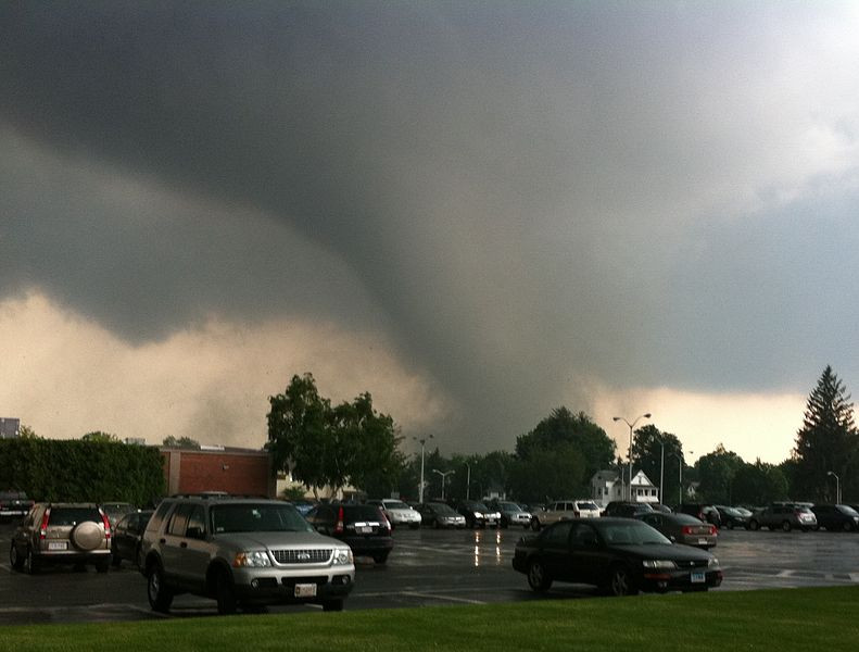
Tornado Warning Issued for RI by National Weather Service: UPDATED SEE OTHER ADVISORIES
Saturday, August 04, 2018
The National Weather Service has issued a tornado warning for Rhode Island as well as portions of Massachusetts. See additional storm warnings below.
Severe Weather Statement:
At 931 AM EDT, a severe thunderstorm was located near Woodstock, or 16 miles northeast of Mansfield, moving northeast at 35 mph. HAZARD...60 mph wind gusts. SOURCE...Radar indicated. IMPACT...Expect damage to trees and power lines. * Locations impacted include... Worcester, Shrewsbury, Grafton, Webster, Southbridge, Auburn, Burrillville, Northbridge, Oxford, Uxbridge, Millbury, Charlton, Dudley, Thompson, Sturbridge, Sutton, Douglas, Woodstock, Mendon and Millville. PRECAUTIONARY/PREPAREDNESS ACTIONS... For your protection move to an interior room on the lowest floor of a building. Torrential rainfall is occurring with this storm, and may lead to flash flooding. Do not drive your vehicle through flooded roadways. && LAT...LON 4227 7175 4206 7156 4192 7210 4203 7214 TIME...MOT...LOC 1331Z238DEG 30KT 4200 7208 TORNADO...POSSIBLE HAIL...<.75IN WIND...60MPH
Expected to end by 10:00 AM
See Additional Rhode Island Advisories for Saturday Below
Severe Weather Statement National Weather Service Boston/Norton MA 942 AM EDT SAT AUG 4 2018 CTC013-015-MAC027-RIC007-041400- /O.CON.KBOX.TO.W.0008.000000T0000Z-180804T1400Z/ Windham CT-Tolland CT-Worcester MA-Providence RI- 942 AM EDT SAT AUG 4 2018 ...A TORNADO WARNING REMAINS IN EFFECT UNTIL 1000 AM EDT FOR NORTHEASTERN WINDHAM...NORTHEASTERN TOLLAND...SOUTHEASTERN WORCESTER AND NORTHWESTERN PROVIDENCE COUNTIES... At 941 AM EDT, a severe thunderstorm capable of producing a tornado was located near Woodstock, moving east northeast at 20 mph. As of 941 AM, there has been no confirmed tornado. HAZARD...Tornado. SOURCE...Radar indicated rotation. IMPACT...Flying debris will be dangerous to those caught without shelter. Mobile homes will be damaged or destroyed. Damage to roofs, windows, and vehicles will occur. Tree damage is likely. This dangerous storm will be near... Thompson around 950 AM EDT. Webster, Charlton, Dudley and Douglas around 1000 AM EDT. PRECAUTIONARY/PREPAREDNESS ACTIONS... TAKE COVER NOW! Move to a basement or an interior room on the lowest floor of a sturdy building. Avoid windows. If you are outdoors, in a mobile home, or in a vehicle, move to the closest substantial shelter and protect yourself from flying debris. Heavy rainfall may hide this tornado. Do not wait to see or hear the tornado. TAKE COVER NOW! && LAT...LON 4227 7175 4206 7156 4192 7210 4203 7214 TIME...MOT...LOC 1341Z 250DEG 18KT 4201 7201 TORNADO...RADAR INDICATED HAIL...0.00IN $$ JWD
Severe Thunderstorm Warning
Severe Thunderstorm Warning CTC013-015-MAC027-RIC007-041415- /O.NEW.KBOX.SV.W.0050.180804T1331Z-180804T1415Z/ BULLETIN - IMMEDIATE BROADCAST REQUESTED Severe Thunderstorm Warning National Weather Service Boston/Norton MA 931 AM EDT SAT AUG 4 2018 The National Weather Service in Boston/Norton has issued a * Severe Thunderstorm Warning for... Northeastern Windham County in northern Connecticut... Northeastern Tolland County in northern Connecticut... Southeastern Worcester County in central Massachusetts... Northwestern Providence County in Rhode Island... * Until 1015 AM EDT. * At 931 AM EDT, a severe thunderstorm was located near Woodstock, or 16 miles northeast of Mansfield, moving northeast at 35 mph. HAZARD...60 mph wind gusts. SOURCE...Radar indicated. IMPACT...Expect damage to trees and power lines. * Locations impacted include... Worcester, Shrewsbury, Grafton, Webster, Southbridge, Auburn, Burrillville, Northbridge, Oxford, Uxbridge, Millbury, Charlton, Dudley, Thompson, Sturbridge, Sutton, Douglas, Woodstock, Mendon and Millville. PRECAUTIONARY/PREPAREDNESS ACTIONS... For your protection move to an interior room on the lowest floor of a building. Torrential rainfall is occurring with this storm, and may lead to flash flooding. Do not drive your vehicle through flooded roadways. && LAT...LON 4227 7175 4206 7156 4192 7210 4203 7214 TIME...MOT...LOC 1331Z 238DEG 30KT 4200 7208 TORNADO...POSSIBLE HAIL...<.75IN WIND...60MPH $$ JWD
Hazardous Weather Outlook
Hazardous Weather Outlook National Weather Service Boston/Norton MA 402 AM EDT Sat Aug 4 2018 CTZ002>004-MAZ002>017-026-RIZ001>006-050815- Hartford CT-Tolland CT-Windham CT-Western Franklin MA- Eastern Franklin MA-Northern Worcester MA-Central Middlesex MA- Western Essex MA-Eastern Essex MA-Western Hampshire MA- Western Hampden MA-Eastern Hampshire MA-Eastern Hampden MA- Southern Worcester MA-Western Norfolk MA-Southeast Middlesex MA- Suffolk MA-Eastern Norfolk MA-Northern Bristol MA- Northern Middlesex MA-Northwest Providence RI- Southeast Providence RI-Western Kent RI-Eastern Kent RI-Bristol RI- Washington RI- 402 AM EDT Sat Aug 4 2018 ...FLASH FLOOD WATCH IN EFFECT THROUGH THIS AFTERNOON... This Hazardous Weather Outlook is for northern Connecticut, western central and northeast Massachusetts, and Rhode Island. .DAY ONE...Today and tonight. Please listen to NOAA Weather Radio or go to weather.gov on the Internet for more information about the following hazards. Flash Flood Watch. There is the potential for a few strong to severe thunderstorms today, bringing the potential for locally strong to damaging wind gusts. .DAYS TWO THROUGH SEVEN...Sunday through Friday. Monday and Tuesday... Heat and humidity may reach hazardous levels each afternoon and evening. .SPOTTER INFORMATION STATEMENT... Weather spotters are encouraged to report significant weather conditions according to Standard Operating Procedures. $$
