RI DEM Warns of Rip Tides, High Surf Due to Hurricane Florence

Friday, September 14, 2018


View Larger +

RI DEM warns of rip tides and high surf

The Rhode Island Department of Environmental Management (DEM) is advising the public to use caution along the shoreline due to anticipated rip currents and high surf generated by Hurricane Florence.

Rhode Island state beaches are currently closed for the season and are not staffed with lifeguards.

“Storm-generated waves attract onlookers. Some “storm watchers” put themselves in danger by standing too close to the surf on rocks along the shoreline in fishing areas, breakwalls, and breachways.  DEM urges Rhode Islanders to stay safe by remaining far away from areas where waves might splash over. Individual waves may be more than twice the average wave height. They possess enormous force and can easily sweep a person into the water from what seems to be a safe viewing area. In addition, swells entering some inlets and harbor entrances could cause difficult navigation for operators of small craft,” said the DEM in their press release.

GET THE LATEST BREAKING NEWS HERE -- SIGN UP FOR GOLOCAL FREE DAILY EBLAST

Hurricane Florence

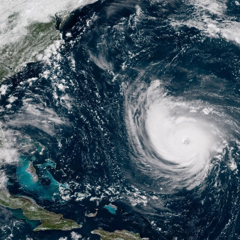
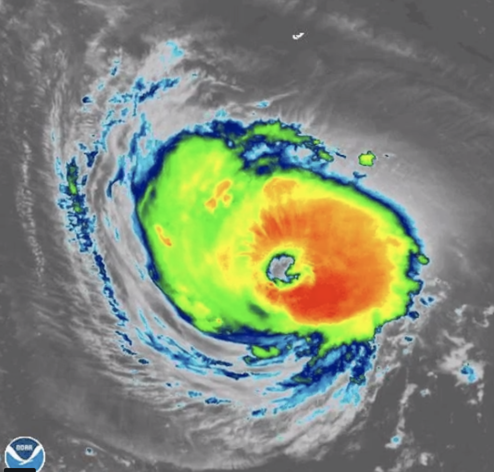
Hurricane Florence is projected to stay offshore of New England, however, the National Weather Service is forecasting that it will bring large swells and dangerous rip currents to ocean-exposed south-facing shorelines over the next several days.

Breakers ranging from 8 feet to 12 feet high are expected in Rhode Island Sound and Block Island Sound.

See 10 Things to Know About Hurricane Florence in the Slideshow Below


Related Slideshow: 10 Things to Know About Hurricane Florence - September 2018

View Larger +
Prev Next

Florence Making Landfall 

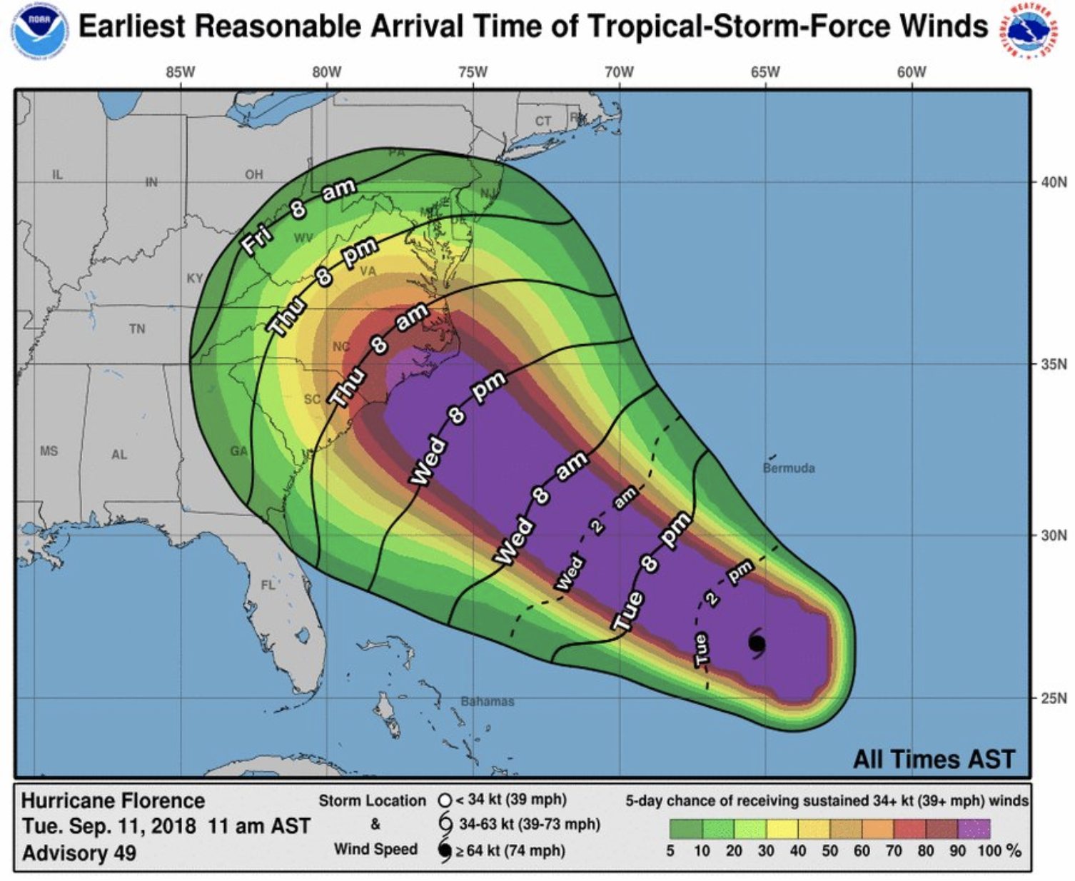
According to the National Hurricane Center, the storm is expected to make landfall by Thursday morning and could be as strong as a Category 3 storm.

However, the center adds that there is a chance the storm reaches land by late Wednesday night. 

"The earliest reasonable time that tropical-storm-force winds could arrive in the United States from #Florence is late Wednesday, and the most likely time is Thursday morning. Wednesday should be the last full day to prepare, so plan accordingly," said the Hurricane Center. 


PHOTO: National Hurricane Center 

View Larger +
Prev Next

58 MPH Winds Possible 

Hurricane Florence could bring winds up to 58 miles per hour to the Carolinas and Virginia. 

"Florence is likely to cause damaging hurricane-force winds along parts of the coasts of South & North Carolina, & a Hurricane Watch is in effect for some of this area. Damaging winds could also spread well inland into portions of the Carolinas & Virginia," said the National Hurricane Center. 


PHOTO: National Hurricane Center 

View Larger +
Prev Next

Evacuations Under Way 

Evacuation has already started in the Carolinas with Hurricane Florence about to hit. 

According to the Washington Post, more than 1.5 million people have been ordered to evacuate the coastal areas ahead of the storm.

“Even if you’ve ridden out storms before, this one is different,” said North Carolina Governor Roy Cooper during a press conference on Tuesday. 

In order to speed up the process, the lanes of the highways have been reversed in order for everyone to be able to get out. 

North Carolina Emergency Management adds that prisons are evacuating staff and offenders to other state facilities due to Hurricane Florence.

Offenders will be given a free call to families this weekend.


PHOTO: Ross Arnette/twitter

View Larger +
Prev Next

NOAA Plane Flies Through Florence 

A plane from the National Oceanic and Atmospheric Administration flew through the eye of the storm. 

via GIPHY

View Larger +
Prev Next

Rainfall Potential from Hurricane Florence 

According to the National Hurricane Center, some parts of the Carolina's could see up to 20 inches of rain. 

According to the chart, most of the area will see at least six to ten inches of rain. 

The Center notes that the forecast is valid until Tuesday, September 18 at 8 p.m. 

View Larger +
Prev Next

Flash Flood Potential 

The National Hurricane Center chart shows that the majority of the area has a marginal to slight chance for flash flooding. 

However, areas right along the coast have a moderate to high percent chance of flooding. 

The forecast is valid through Friday, September 14. 

View Larger +
Prev Next

President Trump Addresses Florence 

President Donald Trump addressed Hurricane Florence in a press conference from the Oval Office on Tuesday, September 11. 

"They haven't seen anything like what's coming at us in 25, 30 years, maybe ever. It's tremendously big and tremendously wet," said Trump. 

Trump went on to advise everyone to get out of Florence's path. 

View Larger +
Prev Next

Biggest Storm Ever North of Florida 

Hurricane Florence could be the biggest hurricane ever to hit north of Florida, according to Business Insider. 

The biggest hurricane to previously hit South Carolina was Hurricane Hugo in 1989.

That hurricane brought 130 mph winds. 

View Larger +
Prev Next

Hurricane Florence 

Here is a scientific look at Hurricane Florence as it approaches the Carolinas. 

via GIPHY

View Larger +
Prev Next

More Storms Coming 

While Florence is the primary focus along the east coast, there are more storms potentially on the way. 

A chart from the National Oceanic and Atmospheric Administration shows that Hurricane Isaac and Hurricane Helene are out at sea.

While still a little ways away, Isaac is currently carrying 70 mph winds and is moving west. 

Helen is carrying 110 mph winds and is moving northwest. 


PHOTO: National Oceanic and Atmospheric Administration 


Enjoy this post? Share it with others.


Sign Up for the Daily Eblast

I want to follow on Twitter

I want to Like on Facebook