
NEW: Winter Storm Could Bring 12+ Inches, John Ghiorse Updates
Tuesday, February 04, 2014
It certainly looks like we're headed into a stormy period. Yesterday's 2"-5" covering of snow across the area may be the kickoff to what could be a series of 3 or 4 coastal storms over the next couple of weeks.
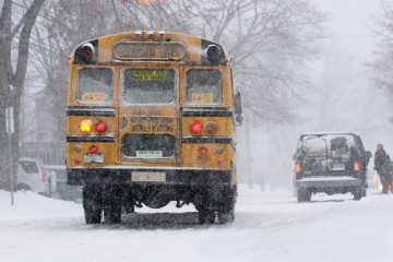
The second in the series should hit us beginning late tonight and extend through much of tomorrow. The trick with this one is trying to determine just where and when snow will become mixed with or change to sleet and rain. That mix or changeover is most likely to happen later tomorrow morning in the area from Providence south and east. That means that the typical snow belt extending from northern and northwestern Rhode Island into Central Massachusetts, including the Worcester area, should see all snow with potential accumulations in the 7"-12" range.
Most of the accumulation in Central and Southern Rhode Island should occur from a couple of hours before sunrise through the morning commute until mid or late morning. The mixed bag precipitation could go back to all snow before ending later in the day. Amounts in those ares should be 3"-7".
GET THE LATEST BREAKING NEWS HERE -- SIGN UP FOR GOLOCAL FREE DAILY EBLASTOf course if the storm track changes, it would alter the above mentioned snow/sleet/rain areas, so I'll have another update later today.
National Weather Service: Winter Storm Warning in effect tonight through tomorrow
URGENT - WINTER WEATHER MESSAGE
NATIONAL WEATHER SERVICE TAUNTON MA
415 AM EST TUE FEB 4 2014
...WINTRY WEATHER WILL RETURN TO SOUTHERN NEW ENGLAND LATE
TONIGHT THROUGH WEDNESDAY...
.LOW PRESSURE WILL DEEPEN OFF THE MID ATLANTIC COAST LATE TONIGHT
BEFORE PASSING SOUTH OF CAPE COD EARLY WEDNESDAY. THE STORM WILL
SPREAD PLOWABLE SNOW FROM WEST TO EAST ACROSS THE REGION AND
PERHAPS A WINTRY MIX TO THE SOUTH COAST.
CTZ002>004-MAZ002>019-026-NHZ011-012-015-RIZ001>004-041715-
/O.UPG.KBOX.WS.A.0004.140205T0500Z-140205T2300Z/
/O.NEW.KBOX.WS.W.0005.140205T0500Z-140205T2300Z/
HARTFORD CT-TOLLAND CT-WINDHAM CT-WESTERN FRANKLIN MA-
EASTERN FRANKLIN MA-NORTHERN WORCESTER MA-CENTRAL MIDDLESEX MA-
WESTERN ESSEX MA-EASTERN ESSEX MA-WESTERN HAMPSHIRE MA-
WESTERN HAMPDEN MA-EASTERN HAMPSHIRE MA-EASTERN HAMPDEN MA-
SOUTHERN WORCESTER MA-WESTERN NORFOLK MA-SOUTHEAST MIDDLESEX MA-
SUFFOLK MA-EASTERN NORFOLK MA-NORTHERN BRISTOL MA-
WESTERN PLYMOUTH MA-EASTERN PLYMOUTH MA-NORTHERN MIDDLESEX MA-
CHESHIRE NH-EASTERN HILLSBOROUGH NH-
WESTERN AND CENTRAL HILLSBOROUGH NH-NORTHWEST PROVIDENCE RI-
SOUTHEAST PROVIDENCE RI-WESTERN KENT RI-EASTERN KENT RI-
INCLUDING THE CITIES OF...HARTFORD...WINDSOR LOCKS...UNION...
VERNON...PUTNAM...WILLIMANTIC...CHARLEMONT...GREENFIELD...
ORANGE...BARRE...FITCHBURG...FRAMINGHAM...LOWELL...LAWRENCE...
GLOUCESTER...CHESTERFIELD...BLANDFORD...AMHERST...NORTHAMPTON...
SPRINGFIELD...MILFORD...WORCESTER...FOXBORO...NORWOOD...
CAMBRIDGE...BOSTON...QUINCY...TAUNTON...BROCKTON...PLYMOUTH...
AYER...JAFFREY...KEENE...MANCHESTER...NASHUA...PETERBOROUGH...
WEARE...FOSTER...SMITHFIELD...PROVIDENCE...WEST GREENWICH...
WARWICK
415 AM EST TUE FEB 4 2014
...WINTER STORM WARNING IN EFFECT FROM MIDNIGHT TONIGHT TO 6 PM
EST WEDNESDAY...
THE NATIONAL WEATHER SERVICE IN TAUNTON HAS ISSUED A WINTER STORM
WARNING FOR SNOW...WHICH IS IN EFFECT FROM MIDNIGHT TONIGHT TO 6
PM EST WEDNESDAY. THE WINTER STORM WATCH IS NO LONGER IN EFFECT.
* LOCATION...SOUTHERN NEW HAMPSHIRE...MOST OF MASSACHUSETTS AS
WELL AS NORTHERN CONNECTICUT AND RHODE ISLAND.
* TIMING...LATE TONIGHT THROUGH WEDNESDAY AFTERNOON.
* ACCUMULATIONS...SNOW ACCUMULATION OF 8 TO 12 INCHES WITH
ISOLATED AMOUNTS OF 14 INCHES POSSIBLE.
* IMPACTS...DIFFICULT TRAVEL CONDITIONS AND REDUCED VISIBILITIES
DUE TO SNOW AND SNOW COVERED ROADS...ESPECIALLY FOR THE
WEDNESDAY MORNING COMMUTE.
* WINDS...WILL BE OUT OF THE NORTHEAST AT AROUND 10 TO 15 MPH
WITH GUSTS UP TO 25 MPH.
* VISIBILITIES...MAY DROP DOWN TO ONE QUARTER MILE OR LESS AT
TIMES.
* TEMPERATURES...IN THE MID 20S.
PRECAUTIONARY/PREPAREDNESS ACTIONS...
A WINTER STORM WATCH MEANS SIGNIFICANT ACCUMULATIONS OF SNOW AND
ICE ARE POSSIBLE. PLAN TO HAVE TRAVEL COMPLETED TUESDAY EVENING.
CONSIDER ALTERING TRAVEL PLANS FOR WEDNESDAY. STAY TUNED FOR
UPDATED INFORMATION.
A WINTER STORM WARNING IS ISSUED WHEN AN AVERAGE OF 6 OR MORE
INCHES OF SNOW IS EXPECTED IN A 12 HOUR PERIOD...OR FOR 8 OR MORE
INCHES IN A 24 HOUR PERIOD. TRAVEL WILL BE SLOW AT BEST ON WELL
TREATED SURFACES...AND QUITE DIFFICULT ON ANY UNPLOWED OR
UNTREATED SURFACES.
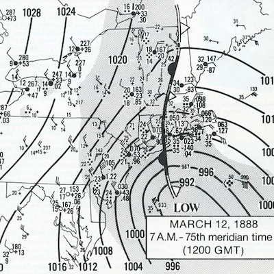
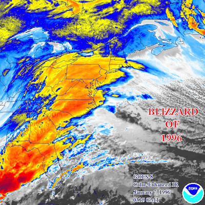
Related Slideshow: Top 10 Blizzards in RI History

.png)


_80_80_c1.png)


Related Articles
- Ghiorse Update on Hurricane Earl: 1:45 pm
- NEW: Adrain Kicks Off Campaign for Providence Mayoral Run
- Ghiorse’s 4th of July Weekend Forecast
- NEW: Taveras Calls on Raimondo to Have Enron Exec $100K Returned
- HURRICANE UPDATE MONDAY EVE: Ghiorse Says More High Winds, Flooding
- NEW: Ruggiero Proposes Waiving Minimum Tax for Startups
- HURRICANE UPDATE: Monday Morning + John Ghiorse’s Outlook
- newportFILM to Host Double Feature Aimed at Children and Adults
- John Ghiorse: Blizzard Conditions Expected in RI Tuesday Afternoon
- Organize + Energize: The 5 Biggest Organizing Mistakes
- John Ghiorse’s Latest Update On Hurricane Earl: THURSDAY AM
- New Competition for HealthSource RI Emerges
- John Ghiorse’s Latest Update On Hurricane Earl: TUESDAY AM
