
HURRICANE UPDATE MONDAY EVE: Ghiorse Says More High Winds, Flooding
Monday, October 29, 2012
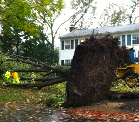
Hurricane Sandy has made landfall in New Jersey, and Rhode Island can expect more dangerously high winds, such as those that have already slammed the state in places like Barrington, earlier. Photo: Heidi Farmer Piccerelli
For Rhode Island: more dangerous high winds, major flooding
The worst part of the wind from the storm for us will continue until later this evening then diminish. East to southeast winds will gust over 50 mph with a few gusts to 65-75 mph for a while longer especially near the coast and over higher terrain inland. The coast and Narragansett Bay communities will continue to experience the worst of Sandy locally with major flooding and destructive wave damage. A coastal surge of 4-6 feet over mean high water this evening as high tide approaches will lower slowly after the 8-9pm high tide. That surge could reach 5-7 feet in the upper portion of Narragansett Bay. As indicated earlier, there will be bands of heavy rain moving through the area but river and stream flooding is not expected to be a big problem.
Heading into tonight
The storm will diminish after midnight but gusty winds and scattered showery periods could persist into Wednesday. For an overview of Sandy in real time, go to GoLocal's Stormpulse map, here.
GET THE LATEST BREAKING NEWS HERE -- SIGN UP FOR GOLOCAL FREE DAILY EBLASTRelated Articles
- Hurricane Sandy in Pictures From GoLocal Readers
- LIVE MAP: Power Outages Across RI
- NEW: Rhode Island Not Planning to Close Highways—Yet
- MONDAY HURRICANE UPDATE: School Closings, Power Outages + More
- Send GoLocal Your Hurricane Sandy Photos
- NEW: Governor Chafee Closes State Offices
- Rhode Island’s Biggest Storms: 75th Anniversary of Hurricane of ‘38
- HURRICANE UPDATE MONDAY AFTERNOON: Height Of The Storm Here Now In RI
- NEW: Governor Chafee Visting Key Areas Around RI As Storm Approaches
- HURRICANE UPDATE: Monday Morning + John Ghiorse’s Outlook
- NEW: Mayor Taveras Activates Providence’s Emergency Operations Center
- HURRICANE UPDATE: RIers With Medical Needs Should Go To Shelters
- NEW: Power Outage Map updated 11:40 am
- How to Throw a Hurricane Party
- NEW: Providence Update—No Trash on Tuesday
