Ghiorse: Weekend Storm Forecast Update
Friday, February 13, 2015
John Ghiorse, GoLocalProv Meteorologist
 View Larger +
Meteorologist John Ghiorse
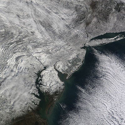
This winter season which started out rather benign has turned into the "Winter From Hell" during the past few weeks. We have had prodigious amounts of snow alternating with bone numbing cold. It now appears that we will be getting both at once this weekend.
The weather map looks rather unimpressive this afternoon, at least as far as storms are concerned. However, that should change dramatically by late tomorrow. A weak, moisture-starved disturbance near Lake Superior will drop rapidly southeastward and explode into an intense storm center just south of Rhode Island by tomorrow night. Then it should curl northeastward toward The Gulf of Maine and Nova Scotia on Sunday.
Because of that track, it looks like the heaviest snow will fall from Rhode Island eastward through Massachusetts, including the hard-hit Greater Boston area, Southeastern Massachusetts, the Cape and Islands with blizzard conditions all along the coastal plain from Maine southward to Cape Cod. Snow accumulations should taper down westward through Connecticut and into Eastern New York.
GET THE LATEST BREAKING NEWS HERE -- SIGN UP FOR GOLOCAL FREE DAILY EBLAST
The snow should begin tomorrow afternoon, become heavy tomorrow night and begin to gradually wind down later Sunday. It is still too early to be confident of snow amounts, but we should see at least 6"-12" throughout Rhode Island and Central Massachusetts with more eastward through Massachusetts, the highest amounts nearer the coast and less westward through Connecticut.
Along with the snow it will be very windy and bitterly cold. Winds may gust over 50mph on Sunday causing considerable drifting and blowing snow. Temperatures in the teens during the storm may well plunge to zero or below Sunday night.
Again, I caution that all of this has not come together yet. As more data comes in there are likely to be adjustments to the forecast.
Related Slideshow: Top 10 Blizzards in RI History
 View Larger +
Prev
Next
10. Blizzard of 2010
Max Accumulation: Approximately 13"
December 26-27, 2010
This winter storm brought more than a foot of snow to several parts of Rhode Island, including 13 inches in Woonsocket.
.png) View Larger +
View Larger +
Prev
Next
9. Blizzard of 2003
Max Accumulation: Approximately 15"
February 14-19, 2013
Know as the President’s Day Storm II, this blizzard brought roughly 15 inches to Ocean State.
 View Larger +
Prev
Next
8. Blizzard of 2009
Max Accumulation: Approximately 16"
December 16-20, 2009
Blizzard warnings were in effect in southern Rhode Island when this storm hit just before Christmas 2009.
 View Larger +
Prev
Next
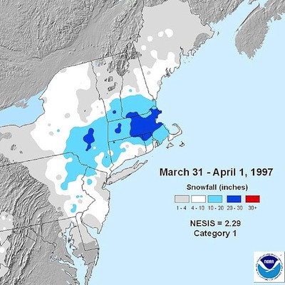
7. April Fool's Day Blizzard
Max Accumulation: Approximately 18"
March 30 to April 1, 1997
This blizzard was no joke when it dropped 18 inches of snow in Providence.
 View Larger +
Prev
Next
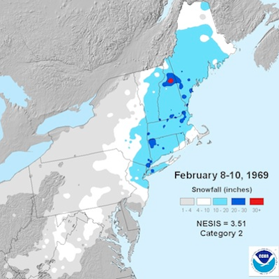
6. 1969 Nor’easter
Max Accumulation: Approximately 20"
February 8-10, 1969
This storm blanketed many parts of Rhode Island with upwards of 20 inches of snow.
 View Larger +
Prev
Next
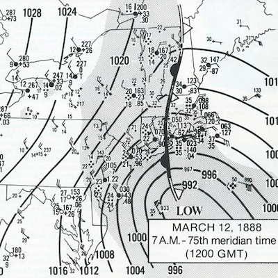
5. Great Blizzard of 1888
Max Accumulation: Approximately 20"
March 11-14, 1888
One of the most severe recorded blizzards in the history of the United States, this superstorm dumped 20 inches in Kingston.
 View Larger +
Prev
Next
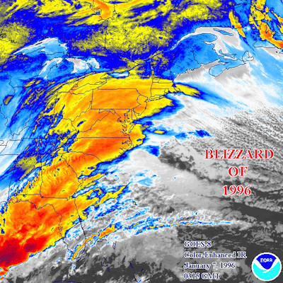
4. Blizzard of 1996
Max Accumulation: Approximately 23"
Jan. 6-10, 1996
One of two blizzards to receive an “extreme” rating on the Northeast Snowfall Impact Scale, this storm blanketing parts of Rhode Island with upwards of 23 inches of snow.
 View Larger +
Prev
Next
3. Blizzard of 2005
Max Accumulation: Approximately 23.5"
January 20-23, 2005
This three-day storm delivered more nearly two feet of snow to some parts of Rhode Island.
 View Larger +
Prev
Next
2. Winter Storm Nemo
Max Accumulation: Approximately 24"
February 7-18, 2013
About 180,000 RI homes and businesses lost power during this powerful blizzard.
 View Larger +
Prev
Next
1. Blizzard of 1978
Max Accumulation: Approximately 38"
February 5-7, 1978
This historic nor’easter, which claimed the lives of 26 Rhode Islanders, brought a record-breaking 27.6 inches of snow to Providence and 38 inches to Woonsocket.
Enjoy this post? Share it with others.


.png)


_80_80_c1.png)


