slides: Getting Out: New England’s 10 Best Bike Trails
Friday, April 04, 2014
GoLocalProv Lifestyle Team
Now that the weather is getting warmer (we hope) it’s time to enjoy all of those activities we had to avoid during those cold winter months. One of the most popular spring-time activities is riding your bicycle throughout your town to enjoy the fresh air or to spend time with friends.
New England has a number of bike paths that allow you enjoy the spring-time, get some exercise and take in some great New England views all at the same time.
Dust off your bike and put on that helmet because it’s time to get riding.
GET THE LATEST BREAKING NEWS HERE -- SIGN UP FOR GOLOCAL FREE DAILY EBLAST
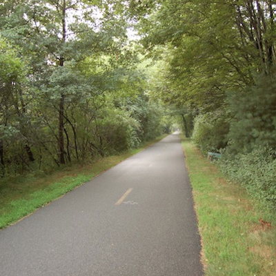
Related Slideshow: Getting Out: Best Bike Trails
View Larger +
Prev
Next
East Bay Bike Path
Though Rhode Island is a small state it is perfect for cycling. The East Bay Bike Path is considered to be one of the prettiest bike paths in Rhode Island and was the first multi-town path constructed in the state. This fourteen mile route runs along the Providence River and Narragansett Bay and ends in Bristol. The East Bay Bike Path is perfect for those who like to bike to work or school or is a fun way to spend a sunny afternoon. For more information, click here.
East Bay Bike Path: Veterans Memorial Parkway, East Providence, Barrington, Rhode Island, 02806
View Larger +
Prev
Next
Blackstone River Bikeway
The Blackstone River Bikeway is Rhode Island’s third largest bike path extending 11.6 miles from Woonsocket to Cumberland. Parts of this path run alongside the Blackstone River and canal making this a scenic route. This path is envisioned to ultimately connect Providence to the Massachusetts border and connect to the East Bay Bike Path. This path shares the roadway with vehicles and is intended for experienced bikers. For more information, click here.
Blackstone River Bikeway: Cumberland Hill, Cumberland, RI, 02864
View Larger +
Prev
Next
Washington Secondary Bike Path
As Rhode Island’s second largest bike path, The Washington Secondary Bike Path extends 14.2 miles from Cranston Street to Central Coventry. Construction has started on this path and when finished the path will run 25 miles from the Connecticut border to close to Providence. For more than half of its length, the path runs parallel to the Pawtuxet River and on-road routes for experienced bikers have been marked by the East Coast Greenway Alliance. For more information, click here.
Washington Secondary Bike Path: Cranston, RI, 02920
View Larger +
Prev
Next
Cape Cod Rail Trail
This Cape Cod bike trail follows the route of a former railroad for 22 miles. This bike path has a paved surface, few hills, and has well-marked automobile crossings making it ideal for cycling. The trail’s unpaved shoulder is also perfect for runners and walkers. The best part of this trail is its location. There are plenty of opportunities to get off the trail and hit the beach so you can rest and enjoy the warm weather. For more information, click here.
Cape Cod Rail Trail: Wellfleet, MA, 02667
View Larger +
Prev
Next
South County’s William C. O’Neill Bike Path
The South County bike path extends 7 miles through the towns of Peace Dale, Wakefield, Narragansett and ends near the Narragansett Town Beach. This path has a gentle hill in the middle of the trail from Kingston Station to Peace Dale and has moderate ups and downs throughout. For more information, click here.
South County’s William C. O’Neill Bike Path: South Kingston, RI, 02879
View Larger +
Prev
Next
Nashua River Rail Trail
The Nashua River Rail Trail travels along numerous scenic overlooks and is a 10 foot wide paved trail that extends 11 miles. The trail extends through the towns of Ayer, Groton, Pepperell and Dunstable. The entire trail is open to pedestrians, bicyclists, inline skaters and wheel chairs. The Ayer trailhead also offers access to commuter rail service between Boston and Fitchburg. For more information, click here.
Nashua River Rail Trail: Groton, MA, 01450
View Larger +
Prev
Next
Ten Mile River Greenway
The Ten Mile River Greenway is one of the few bike paths in Rhode Island that does not follow a former railroad corridor. This path follows the natural contour of the land and provides a scenic ride along the banks of the James Turner Reservoir. The path connects Slater Park in Pawtucket to the Kimberly Ann Rock Athletic fields in East Providence at a distance of two miles. For more information, click here.
Ten Mile River Greenway: Pawtucket, RI, 02861
View Larger +
Prev
Next
Woonasquatucket River Greenway
As a way to renew the area around the Woonasquatucket River in Providence, a bicycle path was constructed. This path links recreational areas, destination sites and the towns of Manton, Hartford, Olneyville, Valley and Smith Hill to each other and to Waterplace Park in downtown Providence. For more information, click here.
Woonasquatucket River Greenway: Johnston, RI, 02919
 View Larger +
Prev
Next
Minuteman Bikeway
The Minuteman Bikeway is known as America’s Revolutionary Rail Trail and passes through the historic area where the Revolutionary War began in 1775. This path has become the perfect place for people to come together, ride their bikes, and walk the path. The path also connects to the Alewife “T” station in Cambridge allowing pedestrians easy access to the subway. For more information, click here.
Minuteman Bikeway: Arlington, MA, 02474
 View Larger +
Prev
Next
Warren Bike Path
The Warren Bike Path is one of the newest bike paths in Rhode Island. This path which opened in 2010 runs one mile from the Kickemuit River to Long Lane, close to the Massachusetts border. This path is mostly level and provides connections to Kickemuit Middle School, Hugh Cole Elementary School, and Warren Recreation Park making it a perfect means of transportation. For more information, click here.
Warren Bike Path: Asylum Road, Warren, RI, 02885
Related Articles
Enjoy this post? Share it with others.


